Showing posts with label adventure. Show all posts

Wednesday, May 24, 2017

Adventure: Aleksander Doba, the Polish Kayaker Who Crossed the Atlantic (three times!)

I love stories of (some would say) crazy adventurers who take on, and often accomplish, goals so daunting it makes my longest paddles seem like a walk in the park. They harken back to days when famous explorers took on life threatening conditions because they didn't really have any other way to gain fame and fortune. We live in a modern world that has many advantages of comfort and relative safety, but sometimes I wonder if we've lost some of our vital spirit along the way. Fortunately, there are a few individuals who remind us by their epic adventures that the marrow of life is still available for those willing to risk and suffer to get at it.

Aleksander Doba appears to be one such individual. I read a post on Men's Journal from 2014 that recounts Doba's paddle across the Atlantic from Portugal to Florida. This was his second crossing, and he estimates that, due to his drift in currents, he paddled some 7,000 miles - this from a 67 year old man sporting a long, grey beard.

Now, I have no intention of embarking on anything vaguely close to the challenges Doba takes on (for example, he's the first person to paddle the length of the Amazon). However, he does inspire me to push my boundaries, and not to use the passing years as an excuse to grow ever more tentative. It reminds me of a great Anthony Hopkins movie, The Edge , where he tries to build Alec Baldwin's confidence for a looming battle with a predatory grizzly bear by repeating "What one man can do, another can do". Certainly not without preparation and training, but theoretically, yes - what what man can do, another can do.

Take a look at the Men's Journal post here:

Men's Journal - A Record-Breaking Atlantic Crossing by Kayak  

**UPDATE** He has now crossed the Atlantic solo THREE times - now at the age of 70. Read the story here Canoe & Kayak: 70-YEAR-OLD KAYAKER CROSSES ATLANTIC, KEEPS GOING   
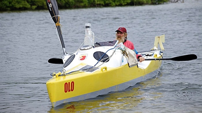

Aleksander Doba transatlantic kayak
Aleksander Doba -  Nicola Muirhead/@nicolaanne_photo 


Keep your spirit of adventure alive, and push your boundaries - no matter how close to home they may be.

- TB on the Water


Wednesday, April 5, 2017

Advice: 5 Tips for Touring a River in a Kayak

If you own a touring style kayak like I do, you are "restricted" to bodies of water large enough to accommodate 14-17' length boats. I put "restricted" in quotes because large bodies of water (lakes, the ocean, bays, etc.) are often anything but restricting in terms of area (conditions may be a different matter). You have plenty of room to turn, plenty of choices in direction, and plenty of depth beneath you. When it comes to rivers, however, those factors can be absent for some or all of the trip. That is why you should carefully choose where to put your touring kayak into a river. 

Rivers come in many forms - wide, narrow, fast flowing, slow meandering, fresh water, salt water...the list goes on. Dams may be present, tides may influence conditions far upriver (read my post Paddle Trip: The Merrimack River - from Rocks Village to Merrimacport), and even the cleanliness of the water can be an issue. How steep are the banks? Do you have anywhere you can get out of the water, or out of the way of boat traffic or the path of a floating log? For instance, kayakers sometimes brave the locks that grant access from Boston Harbor to the Charles Rivers, providing a unique urban kayaking experience. I have to admit, though, the thought of being in a lock, waiting for the water to rise, next to a 25' yacht gives me a sense of trepidation. I'd sure hate to get squeezed against the lock wall by a larger boat drifting in my direction (that doesn't mean I won't try it someday, though 😏).

There's a lot to consider if a river is on your wish list for paddle trips. That being said, a river can offer unique experiences that other venues cannot. You can follow a meandering river upstream into forest or farmland, and get a completely different perspective on areas you drove by or hiked through dozens of times before. Animals are often plentiful at river banks or in the water - deer, birds, turtles, fish...even alligators, manatees, and wild pigs in Florida. If the river is flooded beyond its' typical banks, you might get access to areas you otherwise could not paddle. A few years ago, Tim (see my post An Unexpected Adventure) and I paddled the stretch of the Concord River that flows past the Minuteman Statue and the Old Concord Battle Ground (map here). Paddling around that monument on still, flooded river water was an experience I won't soon forget. Later on the trip, we were able to paddle among flooded hardwood tree trunks - something more usual in cyprus swamps down south. It was a fantastic trip, and an example of the surprises that await you around each bend of a river.


A kayak trip on the flooded Concord River in Massachusetts https://cwkayaker.blogspot.com/2017/04/touring-river-in-kayak.html
Paddling the Concord River

Here's a few tips to help plan your river adventure:

1. Select a river or tributary wide enough for your kayak. If your kayak is of a touring style, choose a river wide enough to comfortably accommodate your boat sideways from bank to bank with enough clearance to turn fully in the opposite direction. Otherwise, you might have to get out on the bank, and lift/muscle your 'yak to turn it around before getting back in.

2. Choose a stretch of the river with calm waters. If you want to run rapids, then get a creek boat and a whitewater paddle and take the time to learn properly. Whitewater kayaking is a discipline unto itself, and is not to be taken lightly. There are serious safety concerns that require proper training and planning (read my post on Riptides and Currents). If you're not prepared for that, then scout a nice flat section, do your research to avoid rocks, dams, and choke points - and enjoy a leisurely exploration.

3. Be prepared to portage. "Portage" means, basically, to carry your boat. If you're paddling a shallow river, and hit a spot without enough water to keep from bottoming, then you'll have to get out and lead your kayak, or even carry it, to a deeper section. If you're not capable of doing that, then it's best to turn around and head back.

4. Paddle upriver first. Starting your trip by paddling upriver first will get the hardest effort done when you're at your freshest. Then, in the worst case, you can drift back downstream with the flow. I haven't always followed this advice myself, but trust me, on a long trip, it's sure nice to have the option to float back.

5. Go where the river leads you. Sounds simple, right? But what I mean is that rivers were the highways of this country before we had paved roads, and eventually paved highways. There's a really good chance the river you paddle was navigated in canoes by native peoples long before Europeans showed up. Even after we did, rivers were used as sources of industrial power, trade routes, water for agriculture...they were the lifeblood of our land. When you paddle a river, you are re-tracing history. You can travel them for a unique perspective on a city (like this tour in Chicago), or an exploration of a quiet, dark woods under overhanging branches, or to hear the wind shimmering through marsh grass on a brackish marsh river. 

Rivers can provide a great alternative to ocean paddling in the bumper seasons (see my post 5 Tips for Paddling in the Bumper Seasons) when ocean winds can get uncomfortably cold, or in the heart of summer when access to ocean side parking can be difficult. They offer another facet to your kayaking experiences, and a way for you to see the world you thought you knew with fresh eyes. I can remember slowly drifting around an oxbow bend on a wooded section of the Exeter River in New Hampshire (map here) to see a young buck deer with his nose in the water for a few seconds before he knew I was there, then watching him bound off through the trees on impossibly light hooves. I'll look at the world through those eyes anytime.

- TB on the Water 


Wednesday, March 15, 2017

Advice: Where Should I Paddle? - advice on planning your adventure

It might seem like an obvious point, but identifying where you're going to paddle your kayak is essential, and can be the single most important aspect affecting the experience you'll have. Aside from the particulars of how you're going to get your kayak to, and in, the water (see my post Which Kayak Should I Buy? ), planning a trip suitable to your equipment, your skill level, who (if anyone) you'll be with, the water and weather conditions, the time needed to complete the journey, etc. is the first step in having a great experience. Don't get me wrong - there have been times when I've put my kayak in at a lesser known launch point, and experienced the adventure of dealing with conditions on the fly. Some of these trips have been a revelation. Others needed to be abandoned in short order. I feel confident (maybe overly confident 😏) in my experience in recognizing safety hazards (see my post Safety is a Mindset ) and other difficulties. I wouldn't recommend "winging it", though, to anyone new to the sport - or, in general, if you can avoid it. Planning your trip can seem like work, but it is also where you can explore your sense of adventure, and anticipate opportunities that might be available.

Instead of listing suggestions on how to plan your trip, I'll describe one that Tim (see An Unexpected Adventure) and I took a few years ago that still stands out in my memory as one of my most enjoyable...

For a short time, many years ago, I lived in Portland, Maine, across from a park (The Eastern Promenade, or "East Prom" satellite view Google Maps) that sits at the shore of Casco Bay. The location of the park, its large parking lot, and both boat ramp and beach access to the water lingered in the back of my mind as a possible launch location, long after I moved away from Portland. Many islands were visible on Google Maps as possible rest/exploration points (including Fort Gorges on a nearby island). There appeared to be coves and other shelters from any challenging conditions we might encounter, and the availability of a route that could "hug" the coastline of larger islands - making a short swim to shore possible in case of an emergency. Also, the larger islands are populated, so communication for emergency help should have been available if needed. Add a stop in the "Old Port" of Portland's downtown for a cold local beer at the end of the trip, and who could resist?   

That being said, Casco Bay is a large body of water, with boat traffic, working fishermen, tankers coming in to Portland, currents unknown to me, and the inevitable surprises that each trip brings. So, I lobbied Tim to come along, which wasn't really a hard sell considering the features I mentioned in the previous paragraph. We launched from the beach at the East Prom on a hot summer day, and paddled across a busy boat lane to take a close-up look at Fort Gorges. I like to plan an early stop, if possible, to assess any gear issues, and to generally make sure I'm feeling good about the location. We both felt confident, there weren't any gear issues, and the weather, though hot, was perfect for a day on the water. And, as it turns out, we could beach the boats for a little while and explore the abandoned fort, have a snack, and spend some time jumping off a short wall into the water below. So far, so good.


The entrance to Fort Gorges, near Portland, Maine in Casco Bay https://cwkayaker.blogspot.com/2017/03/where-should-i-paddle-planning-your.html
Fort Gorges entrance, Casco Bay
A view of the interior of Fort Gorges, near Portland, Maine in Casco Bay https://cwkayaker.blogspot.com/2017/03/where-should-i-paddle-planning-your.html
View of Fort Gorges interior

When we got back in the kayaks, we proceeded past walls of the fort that rise high and straight out of the water, and to the east, where we hugged the southern and eastern shores of Little Diamond Island. Passing the large pier at the southern end of Little Diamond, I logged it in my memory as a location feature ( a breadcrumb, if you will) to look for on our return trip. Being among islands can be disorienting, and can sometimes block the view to your destination. Maps can help, but I tend to use them more for the planning stage, and then use the actual physical characteristics of the area (plus a compass on the front deck of my kayak) to navigate. This strategy also helps keep track of your time - as the return trip should need roughly the same time to execute (providing for currents, wind conditions, and fatigue, of course).

We continued to paddle northeast through Diamond Island pass, past Great Diamond Island, then turned east past Pumpkin Knob and straight out to Overset Island. This is where planning couldn't tell us everything we needed to know. Overset Island, although not far off the coast of the larger and populated Long Island, was much more open to the bay than the previous islands we encountered. The wave actions at its' southern tip was much more like open ocean swell than protected harbor. It was important that we not get too close to it - to avoid any danger of getting tossed onto the rocks, or marooned on a rock top by a retreating wave. Maps can show you only so much, and having experience and a paddle buddy allowed us to continue. Had I been alone, I might have called that the end of my outward journey, and turned back around.

Tim and I discussed our plans at that point, and decided to paddle east to one more island -  Vaill Island. It looked from Overset that Vaill had a little cove with maybe a beach - and I thought I saw a boat anchored there. We paddled over much choppier swell than we had seen inside of Overset Island, and pushed hard to reach the cove. When we got there, we were rewarded with sheltered, calm water and a beach where we could land and take a rest. There was a boat anchored, but aside from the few passengers and their radio, we had the place to ourselves. A nice swim, some bottled water, and a half hour rest prepared us for the return trip. We picked our way back, a step at a time, passing each of the locations we had visited on the way out. There were a couple of times that I didn't recognize where I was headed, but relying on physical markers, my memory of the map from my planning stage, and my compass, we made our way safely back to the East Prom - and ultimately to Old Port bar stools and frosty mugs of suds. 😋

So, what does this tale have to do with planning where to paddle? First, I had seen the launch location and had reviewed its' suitability for a kayak launch. Then, I followed my hunch and consulted Google Maps to plan a route that we mostly stuck to. I noted features of the trip, like Fort Gorges, that could provide further exploration possibilities, and I left the plan flexible enough to accommodate on-the-spot decisions like continuing to Vaill Island from Overset Island. I also planned the most important aspect of this trip - not going alone (at least on the first one in this area). I didn't really talk about gear preparation for this trip (other than noting my compass), but you can read Safety is a Mindset  - and I'll probably publish some gear specific posts in the future. Let me know in the comments if you'd like to see anything specific.  

Remember, planning your trip is the first step in your adventure. Keep your eyes open, in your travels, for launch locations. Look at maps, read blogs and boards, and create a wishlist of paddling trips. Then, assess your skills, gear, experience and possible accomplices and pick a trip that fits. I got into kayaking to explore, and my planning process is just another aspect of that exploration. When I'm doing my research, I can almost see the adventure in my mind. The only thing better is actually paddling it - especially if you planned well. And, don't forget to plan a reward after a hard day paddling. Sitting on a bar stool, drinking a cold beer and eating a burger in the Old Port was the perfect end to one of my best paddle trips.

- TB on the Water      


Wednesday, March 1, 2017

Story: An Unexpected (and hair raising) Adventure

I used to travel daily for work around the northeastern counties of Massachusetts, namely Essex and Suffolk counties. This is basically the seaboard and adjacent towns that run northeast of Boston to the New Hampshire border. One of these communities located directly on the water is the picturesque, and still working, port of Gloucester (see my post Location: The Mouth of the Danvers River & Nearby Islands). Gloucester harbor resides near the tip of Cape Ann - not as far east as Rockport, but close. The harbor and nearby waters open to the south of Cape Ann, while the Annisquam River connects both the southern and northern coasts of Cape Ann (the much smaller and rockier contrast to the well known Cape Cod, which juts into the ocean from southeast of Boston).   . 

I am always on the lookout for a paddle adventure when I am near the ocean, and one workday two summers back, I happened upon the public boat launch near Gloucester High School, which affords parking and a launch point into the Annisquam. The idea occurred to me to launch from this point, paddle south under the Blynman Canal drawbridge (which I have heard is the second busiest drawbridge on the entire eastern seaboard), and head west along the coast past Magnolia (a section of Gloucester). There are several islands located near the rocky Magnolia coast (the front yards of mansions and large shingle style homes) that are accessible for a lunch and beer break (thankfully, many craft beers are now available in cans 😈). 

A few days later, I proposed my idea to my frequent paddling buddy, Tim. Tim and I got into paddling touring length kayaks many years ago, and Tim has been a good natured participant in many of my planned excursions. Some trips have lived up to my expectations, and some have been a hard slog, with many a lesson learned. This particular excursion started as the former, but ended as the latter - by far.

The day was a sunny, hot, mid-summer beauty that brings New Englanders to the shore in droves. We got an early enough start to avoid significant boat traffic under the drawbridge (more on that later), and made our way into the outer harbor past Stage Fort Park. The wind was blowing lightly from the southeast, and the chop it caused was small enough that paddling progress was not affected significantly. Everything appeared to be set up for a mildly challenging and enjoyable afternoon on the water.

Once we turned the corner past a rocky outcrop at the western edge of the greater harbor, I noticed the chop and swell took on a more "open ocean" feel. Waves were crashing onto the rock formations and cliffs to our starboard (right) side, so we stayed far enough away to avoid getting caught in anything dangerous. The conditions at this point were just about perfect. There is a feeling of freedom paddling a kayak in open water conditions that fosters a spirit of adventure a bit more emphatic than the feel of paddling a flat backwater. 

The increased swell and chop, as well as an increased wind speed, slowed our progress. So, we adjusted our plans, and shortened our destination to Kettle Island, just south of Magnolia Harbor  GOOGLE MAP of MAGNOLIA COAST  . We beached the boats on the sandbar between Kettle Island and the smaller rock to the north, and settled in for a rest, some lunch, and a tasty beer. We had the place to ourselves, with the exception of two other kayakers and an abundance of squawking seagulls. After we had a sandwich, we made the mistake of attempting to explore the island, and stumbled into the midst of a seagull rookery. Alarmed and swooping gulls harassed us until we made our way back to the beach, where we could find some peace.

After maybe an hour, we decided to head back east along the coast - realizing we would be headed more directly into the wind, which would impede our progress and increase the time needed to get back. I noticed some small waves breaking onto the sandbar, and suggested we play in the waves for a few minutes as we launched. We pretty quickly realized the swell had grown in the hour we were beached, and the waves crashing onto Magnolia proper were 3-5 feet. Playing in the swell was quickly adjusted to dealing with the conditions to avoid capsize or getting pulled onto the rocks. I realized the conditions on the way back would be far more difficult than on the way out: the swell was coming from the southeast, but crossing currents were causing waves from the northeast as well. In order to keep our bows pointed toward the swell (the safest alignment to avoid capsize), we would be travelling farther out to sea - which was not what we wanted. We were forced to adopt a pattern of paddling southeast into the swell for a bit, then readjusting to a northeast direction - which had us "surfing" the swell at a 45 degree angle. This was not ideal, but was the only way we could somewhat safely progress in an easterly direction back toward Gloucester and the safety of the harbor. 

At one point, I looked to my left and saw Tim get a little too straight in front of a swell wave. Some of them were now big enough to break a bit at the top. Tim slid down the face of the wave into the trough, and his bow plunged into the water. He was in danger of "pearling" (driving the front of the boat under water, which slows the bow speed relative to the stern speed, and can cause the kayak to capsize). Tim maintained his balance, used his paddle to brace, and pulled his bow clear, but it was a narrow escape. I eyed the waves crashing onto the rocks warily, and realized if Tim had a wet exit (he was in a hulled boat), getting back into his kayak would be extremely challenging in this swell, and swimming to shore would be treacherous. I had visions of a water laden kayak crashing onto the rocks - heavy and out of control. Although I was on my Heritage Sea Dart sit-on-top, even I was concerned about getting knocked off it. Climbing back on would be easier than re-entering a hulled boat, but in these conditions, it still wouldn't be a piece of cake.

We paddled like this for a long time - occasionally having to rapidly adjust to a random wave hitting from the northeast instead of the southeasterly swell direction. This kept things interesting to say the least. I kept an eye out for any small cove or calmer spot to give us a reprieve from the conditions, but there were none. It's amazing how good a paddle workout you get when the effort is seasoned with a pinch of panic.  

Finally, I noticed a very small calm area in what was barely a cove. I think it may be called "Old House Cove", but I'm not sure. Anyway, the conditions continued as we entered the harbor, and a few minutes rest in the relatively calmer waters in this cove were a blessing. As we proceeded into the harbor, our direction adjusted more to the north. This put us almost perpendicular to the swell, riding straight down wave faces - which could increase the chance of pearling. Fortunately, the swell abated somewhat as we paddled farther into the harbor and back across Stage Fort Park to the beach. We avoided rock outcrops in the water and navigated safely to the beach, where we hauled out for some much needed rest and relief. I didn't time it (I was a bit too busy keeping my shit together 😁), but my guess is we were paddling for an hour in those conditions. It felt great to put my two feet on the sand again.

Once I had gathered my wits and shaken loose my stiff arms and back, I took a look at the entrance to the canal under the drawbridge - where we had emerged from the Annisquam River. Returning boats were lined up to pass on the east side under the bridge, and many outbound boats were still entering the harbor via the west side. I walked over to the stone wall at the edge of the canal and peered over it to see an outbound current that was significantly stronger than what we had experience on the way out. When we left the Annisquam and paddled under the bridge, the tide had just turned and was inbound. Against the outbound river current, it was largely neutralized, and only posed a minor effort to overcome. Now, the tide was outbound, and, magnified by the outbound river flow, had increased to a speed that required powered boats to re-enter against the flow at near to full throttle. Add to that the relatively narrow width of the canal, which pinches the current and speeds it further, and there was absolutely no way we would be able to paddle back through VIDEO of an ATTEMPTED PADDLE. I realized immediately this route had not been well considered. I had to come up with another plan to get the kayaks back to my truck, which was parked upriver at the public launch near the High School. Well, if I couldn't get the kayaks to the truck, then I would have to bring the truck to the kayaks.


View of the Annisquam River & the ocean beyond

I determined a path I could walk, and crossed two lanes of traffic, now backed up for the regularly raised drawbridge. I found a path down to the east bank of the river, and walked the 1/4 mile to the parking lot at the public launch. Tim stayed with the kayaks to keep an eye on them, and hopefully to direct me to a rare parking spot along the causeway next to the beach. Due to the traffic, I had to drive a large, looping route to get back to the beach from the west. Fortunately, a spot miraculously appeared, and we didn't have to carry the boats too far to get them loaded. 

All in all, what had promised to be a casual day on the water turned out to be a difficult, and sometimes frightening excursion. We were both glad nothing serious happened, but spent a little time talking about what could have happened. Some valuable lessons were learned - not the least of which is that, although I have been paddling for many years, I can always improve my trip planning and my safety gear. Oh, and nothing drives a workout better than a little fear 😅.     

- TB on the Water